Project

GeoKnow is a 3-year project funded by the European Commission within the FP7 Information and Communication Technologies Work Programme (Grant Agreement No. 318159). GeoKnow addresses the problem of linking geospatial data from heterogeneous information systems and uses the web as a platform to exploit this data.

  • We address a bold challenge in the area of intelligent information management: the exploitation of the Web as a platform for geospatial knowledge integration as well as for exploration of geographic information.
  • GeoKnow aims to contribute to the following areas concerned with geospatial data:

    • Creation and maintenance of qualitative geospatial information from existing unstructured data such as OpenStreetMap, Geonames and Wikipedia, anticipating geospatial search and acquisition and aggregation of information resources.
    • Reuse and exploitation of unforeseen discoveries found in geospatial data. GeoKnow will provide methods to acquire, analyse and categorise data that is rapidly evolving, immense, incomplete and potentially conflicting with:
    • Tools and methodologies for mapping and exposing existing structured geospatial information on the web of data, considering comprehensive and qualitative ontologies and efficient spatial indexing.
    • Automatic fusing and aggregation of geospatial data by developing algorithms and services based on machine learning, pattern recognition and heuristics.
    • Tools for exploring, searching, authoring and curating the Spatial Data Web by using Web 2.0 and machine learning techniques based on scalable spatial knowledge stores. All these contributions are integrated in the open source GeoKnow Generator framework developed by the consortium.

A high-level architectural overview

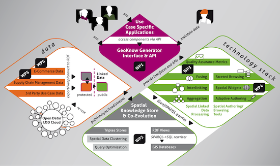
The GeoKnow Generator will provide a comprehensive toolset of easy to use applications covering a range of possible usage scenarios (e.g. mobility/traffic, energy/water, culture, etc) . The GeoKnow project contemplates two application scenarios: a travel e-commerce data management tool and a spatial-semantic collaboration and data integration tool along value-chains in supplier and customer networks. Learn more about GeoKnow, check the detailed work packages of this project:

WP1 Requirements, Design, Benchmarking, Component Integration
WP2 Semantics based geospatial data management
WP3 Spatial knowledge aggregation, fusing & quality assessment
WP4 Spatial-semantic exploration, visualization, analysis & authoring
WP5 Spatial Linked Data in the Supply Chain
WP6 GeoKnow for E-Commerce
WP7 Dissemination, community building, exploitation & standards
WP8 Project Management
  • Duration: 12/2012- 11/2015
  • Total Budget: 4.48 M€
  • Total Funding: 3.24 M€
  • Total Resources: 560 PM

Hosted by

Universität Leipzig , InfAI: Institut für Angewandte Informatik

Funded by

EU Seventh Framework Programme (FP7)

Community and Social Media

Google+

News

EDF2015 and Linked Data Europe: Big Geospatial Data Workshop ( 2015-11-24T23:46:33+01:00 Alejandra Garcia Rojas)

2015-11-24T23:46:33+01:00 Alejandra Garcia Rojas

In 2015, the European Data Forum took place in Luxembourg on the 16th and 17th November. GeoKnow team had the pleasure to be present at the event with a booth for showing GeoKnow results. The conference welcomed over 700 participants from industry, research, policy makers, and community initiatives form all over Europe. Read more about "EDF2015 and Linked Data Europe: Big Geospatial Data Workshop"

Linked Open Data Switzerland at SWBI2015 ( 2015-10-12T09:56:15+02:00 Daniel Hladky)

2015-10-12T09:56:15+02:00 Daniel Hladky

Daniel Hladky from Ontos presented GeoKnow at the SWBI2015 conference two talks. The first talk was the keynote on October 7, 2015 with the title “Linked Data Service (LINDAS): Status quo of the Linked Data life-cycle and lessons learned“. Read more about "Linked Open Data Switzerland at SWBI2015"

FAGI-gis: fusing geospatial RDF data ( 2015-10-05T13:08:20+02:00 Giorgos Giannopoulos)

2015-10-05T13:08:20+02:00 Giorgos Giannopoulos

GeoKnow introduces the latest version of FAGI-gis, a framework for fusing Linked Data, that focuses on the geospatial properties of the linked entities. Read more about "FAGI-gis: fusing geospatial RDF data"

GeoKnow Public Datasets ( 2015-09-19T16:15:29+02:00 Alejandra Garcia Rojas)

2015-09-19T16:15:29+02:00 Alejandra Garcia Rojas

In this blogpost we want to present three public datasets that were improved/created in GeoKnow project. LinkedGeoData Size: 177GB zipped turtle file URL: http://linkedgeodata.org/ LinkedGeoData is the RDF version of Open Street Map (OSM), which covers the entire planet geospatial data information. Read more about "GeoKnow Public Datasets"

GeoKnow at Semantics 2015, Vienna ( 2015-09-18T15:12:48+02:00 Alejandra Garcia Rojas)

2015-09-18T15:12:48+02:00 Alejandra Garcia Rojas

Several partners of GeoKnow were present this year at the Semantics conference 2015. The previous day of the conference we organised a workshop about the work done during these last three years in GeoKnow. Read more about "GeoKnow at Semantics 2015, Vienna"